By Lance Gloss
 Spring Creek runs through Fort Collins to meet Colorado’s Cache La Poudre River. Where the creek flows under a bridge near the Dairy Queen, a placard marks the high-water line of the 1997 Spring Creek Flood. That storm was what experts call a 500-year flood. Statistically, such an event has a one-in-five-hundred chance of occurring in a given year, based on historical data.
The event was horrific by all accounts. More than a foot of rain fell in Fort Collins on a summer day, sending a 15-foot surge of water down the channel and killing four people at a mobile home park near what we always called the Dairy Queen bridge. The bridge today simply carries traffic and allows water to pass through, but the placard on the bridge turns it into a physical manifestation of the event. With or without a high-water marker, though, a bridge is always more than a bridge.
A bridge, says Kory Wilmot, AICP, expresses an understanding of the future. Where a bridge begins and ends, how high it stands, what materials comprise a bridge – these features represent how the builders expect water to flow in fifty or one hundred years while a bridge is still in use.
The details of a bridge, and the future it represents, draw on expectations shaped by the past. Records of high water from 500-year floods – whether or not they are actually noted by a placard – are one type of information that engineers use to make infrastructure decisions in the present that will have decades of impact.
One of the great resiliency challenges faced by communities in this era of rapid climate change is that the past is no longer such a useful guide to the future. What was once a 500-year flood may no longer be so rare. Rather, we now expect change, and lots of it, in ways that we struggle to accurately predict. How, then, do we make decisions about a bridge today?
These are the kinds of resiliency questions that Wilmot addresses as an urban planner and project manager with the consulting firm AECOM. Wilmot has supported communities nationwide in establishing plans for community development, hazard mitigation, and disaster recovery. He recently shared lessons from his career in resilience planning with students at UNC, hosted by the Coastal Resilience Center in partnership with UNC’s Department of City and Regional Planning.
Wilmot zeroed in on ways in which planners can support communities in their hazard mitigation and disaster recovery planning. Planners play an essential role in creating the hazard mitigation plans that communities must produce and revise every five years under the Disaster Mitigation Act of 2000. This includes setting priorities on how disaster recovery funds would be spent. It also includes assessing what costs would arise form a disaster and how those costs can be minimized by policies and development decisions.
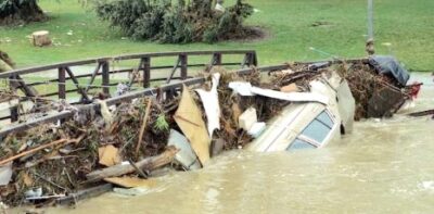
Image: “Spring Creek Flood anniversary: Revisit the deadly night.” Erin Udell. The Coloradoan. July 20, 2017.
Just as importantly, Wilmot charged planners with ensuring that thinking about disasters and uncertainty infuses the many types of plans communities produce. It is not enough to have a hazard mitigation plan on the shelf if the comprehensive plan, housing plan, and transportation plan ignore natural hazards and shifting climatic regimes. Planners must ensure that housing and critical infrastructure aren’t built in hazard-prone areas, as these decisions are challenging and expensive to reverse once made.
By integrating across plans, urban planners can guide where, and which, new infrastructure will be built. In Fort Collins for example, the City has installed early warning system of rain gauges, new green infrastructure, and new floodplain management regulations. All major City of Fort Collins planning documents now reflect concern for flooding, including the recently-adopted and comprehensive City Plan.
Kory Wilmot’s role as a consultant often has him playing this role for small communities that don’t have the resources to develop hazard mitigation plans on their own. This has given him a unique vantage point. He notes that Towns face unique combinations of hazards and contexts that set them apart. One thing they all have in common is the need for everyday infrastructure. In short, every community has its equivalent of Fort Collins’ “Dairy Queen bridge.”
One great power of infrastructure is its “infra” quality. The word-part signifies “below.” Infrastructure, then, speaks to changes we make to the landscape that become ordinary and accepted. By planning for hazards and integrating hazard planning into transportation, housing, and more, planners can ensure that the infrastructure we build today shapes our everyday thinking to reflect the uncertain and hazardous future we face.