Coastal Resilience Blog

News and perspectives from the DHS Coastal Resilience Center of Excellence at UNC-Chapel Hill

Page 3 of 7

Army Corps speaker highlights coastal resilience projects across country

A graphic from the U.S. Army Corps of Engineers' New Jersey Back Bay Study details one of several options for defending shorelines.

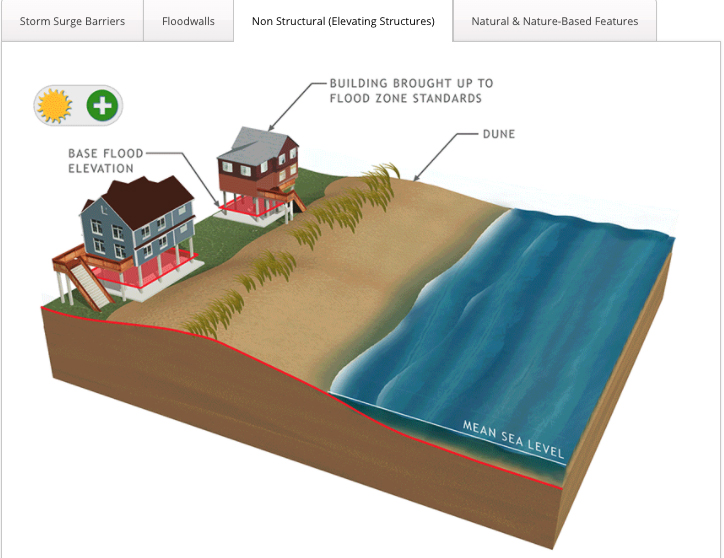
A graphic from the U.S. Army Corps of Engineers’ New Jersey Back Bay Study details one of several options for defending shorelines.

By Lauren Turner

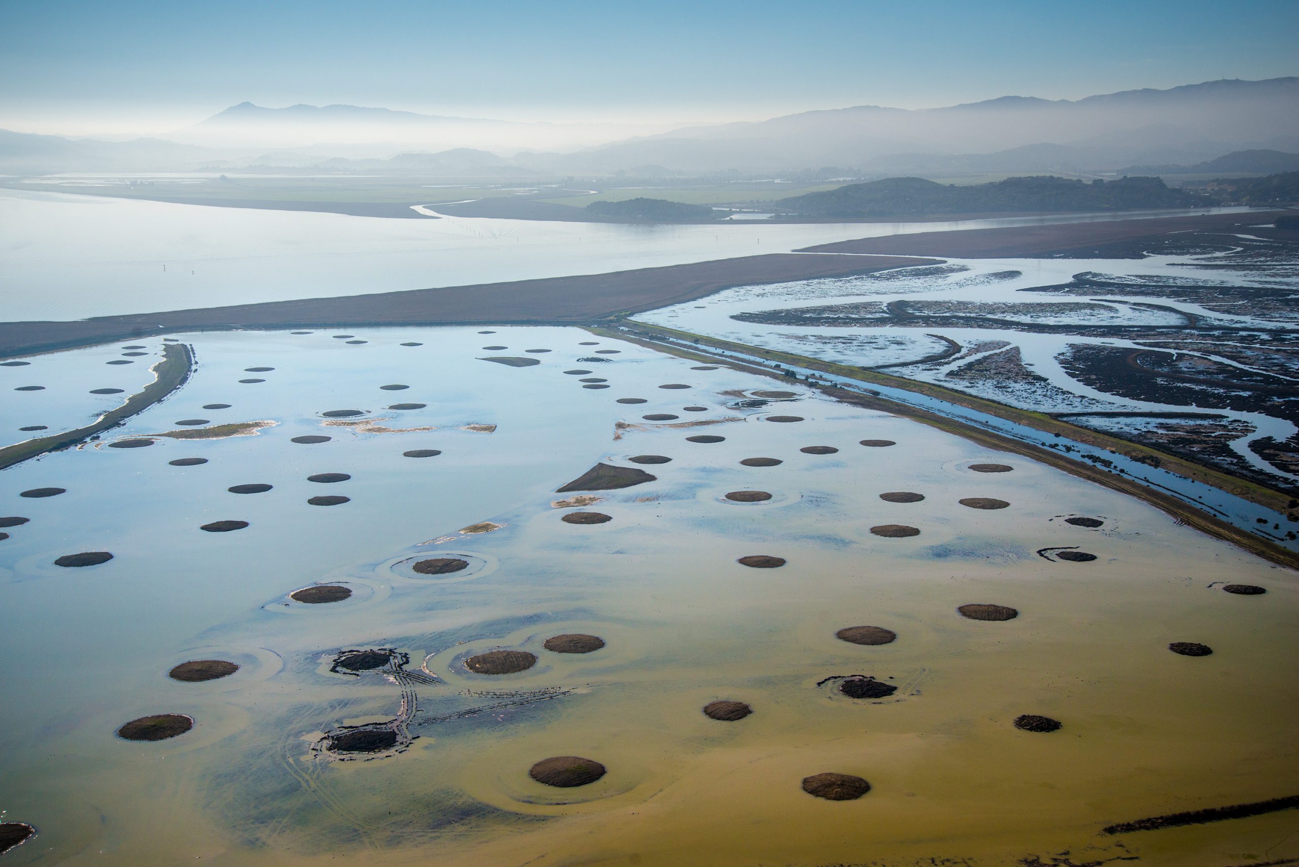
On April 16, 2020, the Natural Hazards Speaker Series was joined by J.B. Smith of the U.S. Army Corps of Engineers (USACE). Smith is the Coastal Technical Expert for the Philadelphia District of the Corps. He spoke about the planning perspective of the Corps around coastal hazards and resilience. Earlier this semester, we heard from his Army Corps colleague, Julie Rosati, who presented the programmatic model of the Corps. Smith’s presentation was a follow-up on that, delving into specific programs (namely the New Jersey Back Bay) as well as barriers to implementing preferred techniques.

JB Smith

JB Smith

Smith works in the Coastal Storm Risk Management program, which focuses on beach erosion and restoration, shoreline protection, urban inundation and sea level rise. Smith said USACE addresses these issues through engineering and practice-based solutions. Many projects take up to 10 years, and the Corps is constantly conducting research to propose new and better solutions. As Smith puts it, “The Corps is the nation’s engineers”.

The planning process that the Army Corps uses is as follows: (1) Identify problems and opportunities, (2) inventory current conditions and forecast future ones, (3) formulate alternative plans, (4) evaluate alternative plans, (5) compare alternative plans and (6) select a plan. Smith said that at each stage of this planning process, there is more opportunity for community engagement, and more stakeholders become involved at each level.

Continue reading

Norfolk adopting resilience strategies in the face of rising seas

Norfolk's susceptibility to flooding from storm surge, from the city's plaNorfolk2030 planning publication.

Norfolk’s susceptibility to flooding from storm surge, from the city’s plaNorfolk2030 planning publication.

By Julianna Schroeger

On March 26, Paula Shea, an alum of UNC’s City and Regional Planning program, and Chief Planner for the city of Norfolk, Virginia, presented to our class about the resilience initiatives southeastern Virginia has undertaken. Shea kicked off the presentation, which was part of the Natural Hazards Resilience Speakers Series, by acknowledging the role of resilience in responding to crises such as the COVID-19 pandemic we find ourselves in now. She noted how the use of technology and ability to adapt classes, jobs and even public meetings to virtual formats serves as a prime example of a resilient strategy.

Paula Shea

Paula Shea

Norfolk, with its 144 miles of coastline, is a city that relies heavily upon its coastal resources. Norfolk is home to the world’s largest naval station and the third-busiest port on the East Coast of the United States. At the same time, Norfolk and the southeastern Virginia region as a whole has a long history of flooding and faces increasing challenges due to rising sea levels and more extreme storms. Shea dated the city’s flooding back to the 1700s, when a hurricane in 1749 shifted the topography of the land, adding several acres of sand bar to the city’s boundaries. The community of Willoughby was subsequently developed on that new dry land but is now among the most vulnerable in the region to flooding. Additionally, sea level is rising in southeastern Virginia faster than the global average, compounded by land subsidence at a rate of about 2 millimeters per year. The region is especially vulnerable because of this, and is frequently inundated by flooding from high tides, heavy rain and storm surge.

The city’s historical connection to the water, reliance upon coastal industry and its vulnerability to coastal changes accelerated by climate change makes it a particularly important place to develop and implement resilience strategies. Shea reviewed the hard infrastructure improvements that city engineers have pursued to address local flooding issues and emphasized the important role that planners play in including residents in community resiliency projects. Norfolk began its resilience planning in 2013 when it joined the 100 Resilient Cities initiative. Continue reading

Hazards modeling predicts flooding from coastal storms

The National Flood Hazard Layer is a geospatial database that contains current effective flood hazard data. The Federal Emergency Management Agency (FEMA) provides the flood hazard data to support the National Flood Insurance Program. Image via FEMA.

The National Flood Hazard Layer is a geospatial database that contains current effective flood hazard data. The Federal Emergency Management Agency (FEMA) provides the flood hazard data to support the National Flood Insurance Program. Image via FEMA.

By Katie Koffman

On March 5, Dr. Brian Blanton of the Renaissance Computing Institute (RENCI) discussed coastal hazard and risk assessment with our class. He showed us various models used for forecasting and prediction of future climate events while explaining “the trap of binary thinking” regarding climate change. Dr. Blanton was a more technical speaker, but he did an excellent job explaining his research and making it understandable for those who approach climate change from a social sciences perspective.

Dr. Brian Blanton

Dr. Brian Blanton

Dr. Blanton began the discussion by explaining how we perceive risk, hazard, and consequences by demonstrating that binary thinking does not generally characterize how nature operates. On FEMA flood maps, he said, risks can be substantially underrepresented because areas are classified either “in” or “out” of the flood zone. However, when compared with historical damage patterns, many areas “outside” the FEMA floodplain experienced flooding. The primary purpose of the maps is for setting  flood insurance rates, but they are often used for land use planning and determining where to live, as well as other unintended uses. The maps should serve as guidance for decision-making, he said, rather than flooding predictions.

We tend to use the word prediction and forecast interchangeably, Dr. Blanton said, but they indicate different things. A forecast should reflect both the likelihood that an event will occur as well as something about its uncertainty, such as “there is a 70% chance it will rain tomorrow.” A prediction is a statement that an event will occur, at some place and time, without recognition of underlying uncertainty. On the FEMA flood maps, the 100-year floodplain indicates areas that have a 1% chance each year to experience a catastrophic event. Often, people interpret this as an area that will experience a catastrophic flood only once every 100 years. The latter interpretation is problematic because it is not true, and does not convey anything about the uncertainty. Continue reading

Assessing place attachment in the face of growing risks

Dr. Michelle Dovil

Dr. Michelle Dovil. Photo by Dr. Shaleen Miller.

By Anna Gustines

On Thursday, Feb. 27, Dr. Michelle Dovil of Florida A&M University (FAMU) presented research on environmental risk perception and place attachment in coastal North Carolina as part of the Natural Hazards Resilience Speakers Series. Environmental risk perception, a judgment of the adverse consequences of a particular hazard, is influenced by a variety of factors. Age, gender, income, ethnicity, political attitudes, trust in government to manage the risk, religion, environmental attitude, risk salience (how imminent the threat is) and risk characteristics all play a role in a person’s perception. Place attachment is the social bond that people have with their physical place; place attachment is closely related to place identity (“I’m from this place and it’s part of the identity I project to society”) and dependency (having familial ties, owning a business or a home) and is best encompassed by the feeling of a certain place being “home.”

Dr. Dovil’s research, conducted as part of a Department of Homeland Security-organized program and hosted by the Coastal Resilience Center, considered whether increased risk perception can override place attachment, and lead people to consider relocating in the face of sea-level rise and climate change. She and her research team of FAMU undergraduate students found that although place attachment in coastal North Carolina is strong, experiences with flooding and hurricanes are increasing the perceived risk of coastal living, leading residents in Wilmington and Elizabeth City to consider relocation.

Dr. Dovil highlights the two communities surveyed as part of her 2019 project. Photo by Josh Kastrinsky.

Dr. Dovil highlights the two communities surveyed as part of her 2019 project. Photo by Josh Kastrinsky.

Unsurprisingly, the effects of climate change that have the biggest effect on families’ and individuals’ daily lives, like repeated flood and hurricane events that caused significant property damage and property insurance cost increases, were cited by participants as their biggest concerns. However, heat-trapping emissions, sea level rise and climate change were cited as least concerning, indicating that the link between the effects of climate change, and climate change itself, are not being recognized by residents that will feel the effects most acutely. Continue reading

Natural hazards increasing educator burden

Dr. Cassandra Davis addresses a UNC class on Zoom as part of the Natural Hazards Resilience Speakers Series.

Dr. Cassandra Davis addresses a UNC class on Zoom as part of the Natural Hazards Resilience Speakers Series.

By Margaret Benson Nemitz

Dr. Cassandra Davis

Dr. Cassandra Davis

The timing of Dr. Cassandra Davis’s presentation in our Natural Hazards Resilience Speaker Series on February 20 could not have been better planned. Dr. Davis, an Assistant Professor in the Department of Public Policy at UNC, studies how storms and natural disasters impact school communities. We were already planning for a virtual class session on Feb. 20, as both Dr. Davis and Dr. Shaleen Miller, our professor, were attending a conference in Florida. Little could we have known that a (miniature) snowstorm would hit Chapel Hill that day. Chapel Hill-Carrboro Public Schools had closed in anticipation of the afternoon storm, and would remain closed the following day as well. At the time of our call, UNC was in Condition 1, so technically speaking, our class should have been canceled as well. Instead, we all called into the Zoom meeting, curled up and stared out the window as the snow fell and we listened to the important work that Dr. Davis is doing.

Margaret Benson Nemitz

Margaret Benson Nemitz

Dr. Davis brought up some critical questions related to how natural hazards impact education systems, many of which she is tackling through preliminary qualitative research and additional research plans. To what extent are school communities really prepared to weather a storm? Although schools are used as shelters during disasters, what happens to the schooling during and after the buildings use as a shelter? How does student attendance, behavior and testing play out following a storm? What are storm impacts on educators? Continue reading

Army Corps work balances economy, flood and storm risks

Sears Point is the site of a Natural and Nature-Based Features wetland restoration project by the U.S. Army Corps of Engineers in San Pablo Bay, Sonoma County, Calif. Photo by U.S. Army Corps of Engineers.

Sears Point is the site of a Natural and Nature-Based Features wetland restoration project by the U.S. Army Corps of Engineers in San Pablo Bay, Sonoma County, Calif. Photo by U.S. Army Corps of Engineers.

By Amy Sechrist

The Coastal Resilience Center (CRC), in partnership with the Department of City and Regional Planning at the University of North Carolina at Chapel Hill (DCRP) welcomed Dr. Julie Rosati on Thursday, Feb. 6, as part of its ongoing Natural Hazards Resilience Speaker Series. Dr. Rosati is the Technical Director in the Coastal and Hydraulics Laboratory for the U.S. Army Corps of Engineers (USACE) in Vicksburg, Miss. Her talk focused on both the history of the Corps and the ways in which they are using field research to address the four main goals of the program.

Dr. Julie D. Rosati

Dr. Julie D. Rosati

Originally, Dr. Rosati said, the USACE Civil Works were charged with three primary missions: navigation, flood and coastal storm risk management, and environmental stewardship. In addition to their national work, Civil Works also provides technical and construction support to more than 100 countries internationally.

While the majority of research and money is funneled towards military research, the Civil Works side of the Corps still plays an integral role in the functioning of our national economy. Indeed, the commercial waterways that Civil Works work to dredge and maintain convey 98% of U.S. imports and exports. Without the Civil Works arm of the Corps of Engineers, Dr. Rosati said, our economy as we know it would cease to exist. Continue reading

Speaker focuses on sustainability of Gullah Geechee Corridor

Albert George, founder of the Resilience Initiative for Coastal Education. Photo by Dr. Shaleen Miller.

Albert George, founder of the Resilience Initiative for Coastal Education. Photo by Dr. Shaleen Miller.

By Olivia Raines

On Jan. 30, I had the chance to hear from founder of the Resilience Initiative for Coastal Education (RICE), Albert George. George came to speak to students across various disciplines enrolled in the Natural Hazards Resilience Speaker Series, and share his experience performing on-the-ground participatory research to address natural hazard mitigation in the Lowcountry of South Carolina. His primary focus is in the Gullah Geechee Corridor, a stretch of coastal areas and islands along the Carolinas, Georgia and Florida, primarily comprised of West African descendants from the transatlantic slave trade.

The Speakers Series brings experts to UNC-Chapel Hill’s campus to speak to Natural Hazards Resilience certificate students annually during the spring semester.

Olivia Raines

Olivia Raines

George spoke to the intersection of race and natural hazards mitigation, and is providing technical support through RICE to advocate for communities such as the Gullah Geechee that are typically left out of conversations around climate change and hazard mitigation. This is becoming increasingly critical, he said, as the low-lying coastal communities of South Carolina are facing imminent sea level rise in the coming years, and currently suffer persistent flooding due to rising ground water levels. George said that it is anticipated that Charleston, S.C., could be experiencing 180 days of flooding per year in the coming decades. He has been working within the Gullah Geechee Corridor for years, and is primarily focused on providing the Gullah Geechee community with access the technology and tools that they can use to, as he put it, “Hold their own flame.” Continue reading

A conversation on statewide resilience

By Sarah Lipuma and Margaret Benson Nemitz

Amanda Martin, Deputy Chief Resilience Officer for the state of North Carolina, came to speak to our class for the UNC Natural Hazards Resilience Speakers Series on Jan. 23.

Amanda Martin

Amanda Martin

Martin engaged the room by asking us what we would do with $500 million to distribute as the state’s new resilience officers. Some students suggested doing studies on the public health impacts of frequent flooding; others thought of specific infrastructure improvements to reduce flooding; and one recommended making sure that rebuilding jobs went to unemployed local community members first. The students, from UNC’s Planning and Public Health programs, as well as Duke’s Nicholas School of the Environment, needed no help thinking up hard-hitting questions for this experienced natural hazard planner.

Martin was speaking as part of the Natural Hazards Resilience Speaker Series, which brings experts to campus to speak to Natural Hazards Resilience certificate students annually during the spring semester. A former student in these same certificate courses, Martin focuses on housing issues at the North Carolina Office of Recovery and Resiliency (NCORR), a relatively new statewide office established to aid in recovery from multiple recent hurricanes. Her office administers federal funds from the U.S. Department of Housing and Urban Development through the Community Development Block Grant – Disaster Recovery Program. While mitigation grants from the Federal Emergency Management Agency are distributed by the North Carolina Department of Emergency Management, when it comes to getting residents the help they need after a disaster strikes, the two state departments try to make their programs as streamlined as possible to avoid complicating the recovery process. Continue reading

Class learns about UNC’s district energy system


UNC-Chapel Hill's cogeneration plant. Photo from the North Carolina Legislature.

UNC-Chapel Hill’s cogeneration plant. Photo from the North Carolina Legislature.

By Amy Sechrist

Have you ever wondered how your physics class is heated? How the student union stays cool in the summer? Or even just what powers the lights in the library? These questions might not seem that interesting, but when you consider that a campus like the University of North Carolina at Chapel Hill has more than 175 buildings to heat, cool and power, these questions become vital for sustainability.

Amy Sechrist

Amy Sechrist

It may not be as trendy as reusable bags, metal straws or other recent trends, but creating more sustainable energy systems has a huge impact on the environmental footprint at an institution like UNC. Thankfully UNC has acknowledged both ends of the sustainability spectrum with its development of the Three Zeros Initiative.

Amy Armbruster, Research and Outreach Manager for the Three Zero Initiative, describes the programs goals of net zero water, zero waster to landfills and net zero greenhouse gases as “huge, bold, ambitious goals,” but the program has already made progress towards all three since its launch in the fall of 2016.

But back to the question of how UNC heats, cools, and powers all of the buildings on campus. For the answer we turn to Adam Long, a Greenhouse Gas Specialist at UNC. During the Jan. 16 Natural Hazards Resilience Speaker Series event and tour of campus facilities, Long provided details about the systems that make UNC run smoothly. Continue reading

HazNerds offers interdisciplinary gathering space for students

HazNerds logo

By Olivia Vilá, North Carolina State University

Once a week for the first semester of my PhD program, I would commute from Raleigh to Chapel Hill and back on the public bus, since I didn’t have a car, to be able to attend Dr. Gavin Smith’s Planning for Natural Hazards and Climate Change Adaptation course at the University of North Carolina at Chapel Hill. The return journeys were especially long and tiresome, since the express route had stopped running by the time class ended. Despite arriving home physically exhausted, often after 11 p.m., I always walked through the door feeling mentally energized and inspired. This was because I had spent the evening learning about natural hazards and disasters, not just from Dr. Smith, but from dozens of graduate students from diverse academic backgrounds, including planning, law, economics, anthropology and geography.  Class discussions were impossibly rich as a result of the many perspectives represented in the class, and often illuminated the complexity of the issues being discussed. Our dialogues were true interdisciplinary experiences that planted the seeds for HazNerds, a graduate student group at North Carolina State University (NCSU) for students interested in hazards and disasters.

Olivia Vila

Vilá

The need for a hazard student group was particularly prevalent at NCSU, where graduate students from across the university do hazards-related research but can be disconnected from those who shared similar interests and goals. I began to understand the broad spectrum of graduate students engaging in this type of research when I started working on an interdisciplinary disaster recovery research project after Hurricane Florence in 2018. Not only did I begin to realize there were other “hazard nerds” like me, I was suddenly working side by side with them. At this point, I began to acknowledge a support gap for students like myself.  Although my department, the Department of Parks, Recreation, and Tourism Management, has a great support system for their graduate students, the resources and opportunities they provide to graduate students are, understandably, not tailored to the needs of those engaging in hazard and disaster-related work. This same gap was felt by many other graduate students across many departments on campus. At the time, I relied on resources and opportunities relayed by The Natural Hazards Center (NHC) at the University of Colorado. While they are an excellent resource, my interactions with the NHC felt distant, considering they were nearly 2,000 away and only accessible digitally. Continue reading

« Older posts Newer posts »